The state’s most severe cold weather event is the 2021 winter storm, but 2024 also recorded notable cold periods. While these events weren’t as extreme as record lows from past decades, they highlighted Texas’ vulnerability to cold snaps. Specific instances in 2024 included temperatures in Dallas reaching 10°F and Dallas/Fort Worth seeing 11°F in January.
More recently, 2025 started with a sudden cold snap, with temperatures dipping below freezing on Monday, January 6, 2025. Temperatures dropped even further, leading to snow on January 21, 2025. These temperature dips remind us of Texas’s varied climate, which can shift from scorching heat to sudden freezing temperatures. These fluctuations reaffirm the need for preparedness and infrastructure capable of withstanding severe weather.
Our Methodology
This analysis employs a descriptive approach to review historical cold weather data from reliable sources, including the National Weather Service (NWS), National Centers for Environmental Information (NCEI) and Texas state government agencies. For information regarding the Texas power grid’s performance during these events, we leveraged data from the U.S. Energy Information Administration (EIA). This methodology provides an overview of Texas’ cold weather history and its effects on the state’s infrastructure.
Sources: National Centers for Environmental Information, National Weather Service, US Energy Information Agency
Texas’s Record Low Temperatures
In 2024, Texas recorded very low temperatures across various regions, with winter lows ranging from 10°F to 28°F. The Upper Coastal Region experienced colder winters and milder summers, while the Lower Coastal Region saw slightly warmer winter lows and higher summer minimums. Overall, Texas’ temperature records reflect typical seasonal shifts, with cooler temperatures in the winter months and warmer, humid conditions in summer.
The Coldest Day in Texas History
February 12, 1899, remains the coldest day in Texas history, with Tulia recording a low of 23°F below zero. Unofficial reports from Wolf Creek and Perryton indicated temperatures as low as 30°F below zero. This historic cold wave affected much of the state, with ice coating Galveston Bay. Seminole on February 8, 1933, later tied with this record low.
Statewide Record Low Temperature (2023 to 2024)
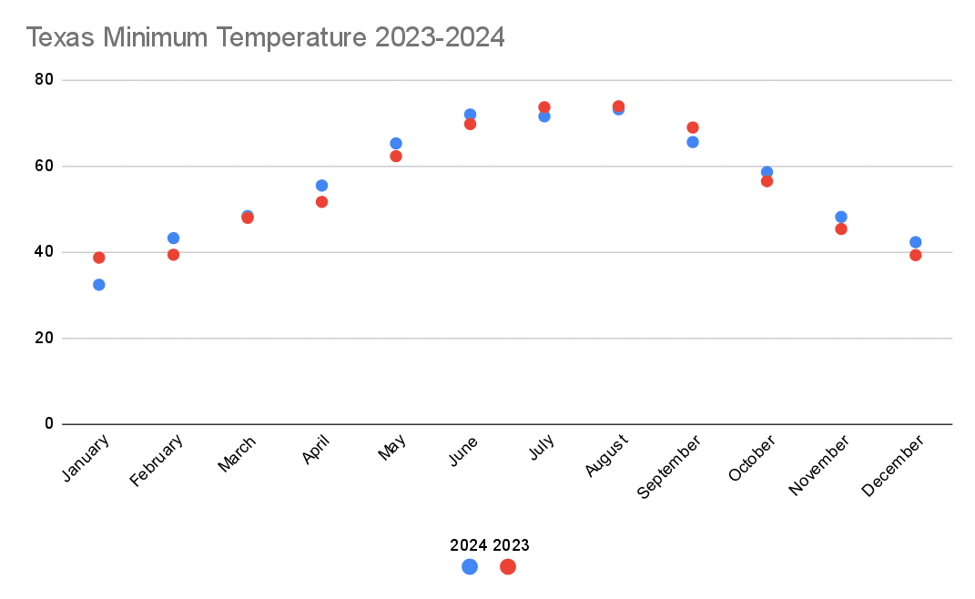
Source: National Centers for Environmental Information
January 2024 recorded a significantly colder average temperature than 2023, with a low of 32.4°F, down from 38.7°F the year before, marking a more severe winter onset. February warmed slightly to 43.3°F in 2024 compared to 39.4°F in 2023. By May, the average climbed to 65.3°F, surpassing May 2023’s 62.3°F, suggesting a warmer spring. In September, temperatures dropped to 65.6°F, lower than 2023’s 69°F, reflecting a cooler late-year transition. December 2024 averaged 42.3°F, slightly higher than December 2023 at 39.3°F. These monthly shifts indicate notable variations in Texas’s temperature patterns between 2023 and 2024.
Below, we’ll break down the record temperatures across Texas by region.
Northern Texas Records
Source: National Weather Service
In 2024, Northern Texas cities recorded their lowest temperatures in January, with Dallas at 10°F and Waco at 12°F, marking the year’s coldest period. August recorded the warmest minimum temperature, peaking at 73°F in Dallas-Fort Worth and 69°F in Waco.
Waco consistently experienced milder summer minimums than the Dallas-Fort Worth area. Transitional months like April (ranging from 42°F to 46°F) and October (42°F to 49°F) showed moderate lows between winter and summer extremes, reflecting Texas’s typical seasonal variability. The annual range highlights the Dallas area’s extremes, spanning from 10°F in January to 74°F in August.
Central Texas Records
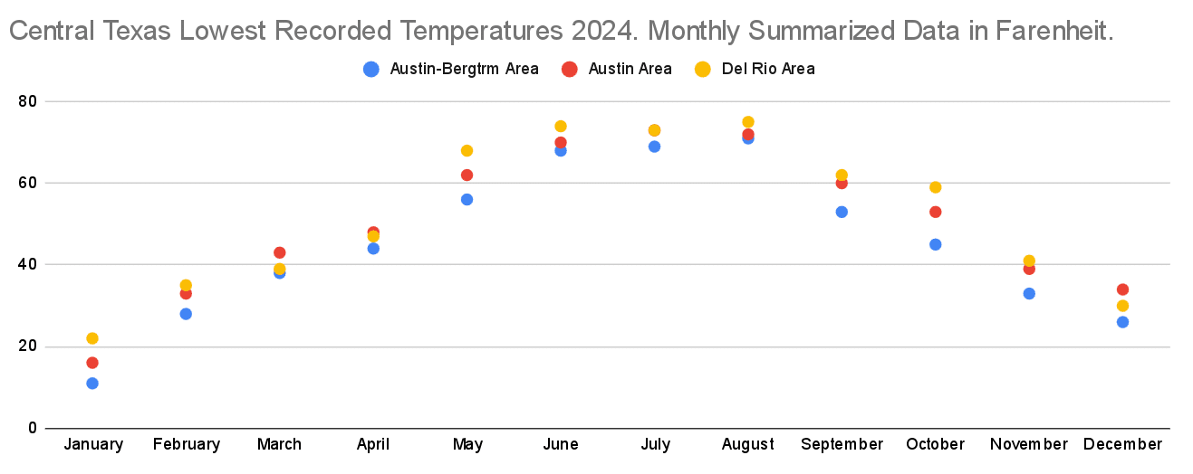
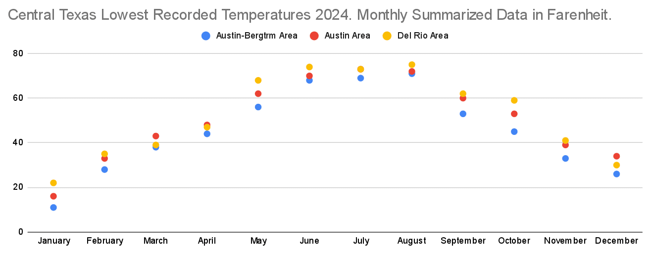
Source: National Weather Service
January marked the coldest month of 2024 for most cities in Central Texas, with temperatures dipping to 11°F in the Austin-Bergstrom area and 22°F in Del Rio, indicating a notably colder start to 2024. February also saw significant low temperatures, with Austin dropping to 16°F and Del Rio to 22°F, reflecting a consistent winter trend. On the other hand, July and August were the warmest months, with Del Rio peaking at 75°F in August, the highest minimum in the dataset, followed by Austin’s 73°F.
Austin’s temperatures were consistently milder than Del Rio’s. While Del Rio saw a sharp dip in temperature at 22°F in January, Austin’s coldest month of 2024 was generally January, with temperatures reaching 11°F in the Austin-Bergstrom area. Transition months like April and October showed moderate temperatures, generally between winter lows and summer highs, with Austin and Del Rio maintaining relatively higher temperatures in April. This reflects a typical Central Texas climate with marked seasonal transitions.
Coastal Region Records
The lowest recorded temperatures in Texas’ coastal regions for 2023 show distinct seasonal trends between the Upper and Lower Coastal Areas. In the Upper Coastal Region, winter lows ranged from 30°F to 44°F, with summer minimums peaking between 74°F and 80°F. In the Lower Coastal Region, winter lows ranged from 32°F to 38°F, while summer minimums reached up to 77°F. These patterns highlight the region’s typical seasonal variations, with cooler winters and warm, humid summers.
Upper Coast
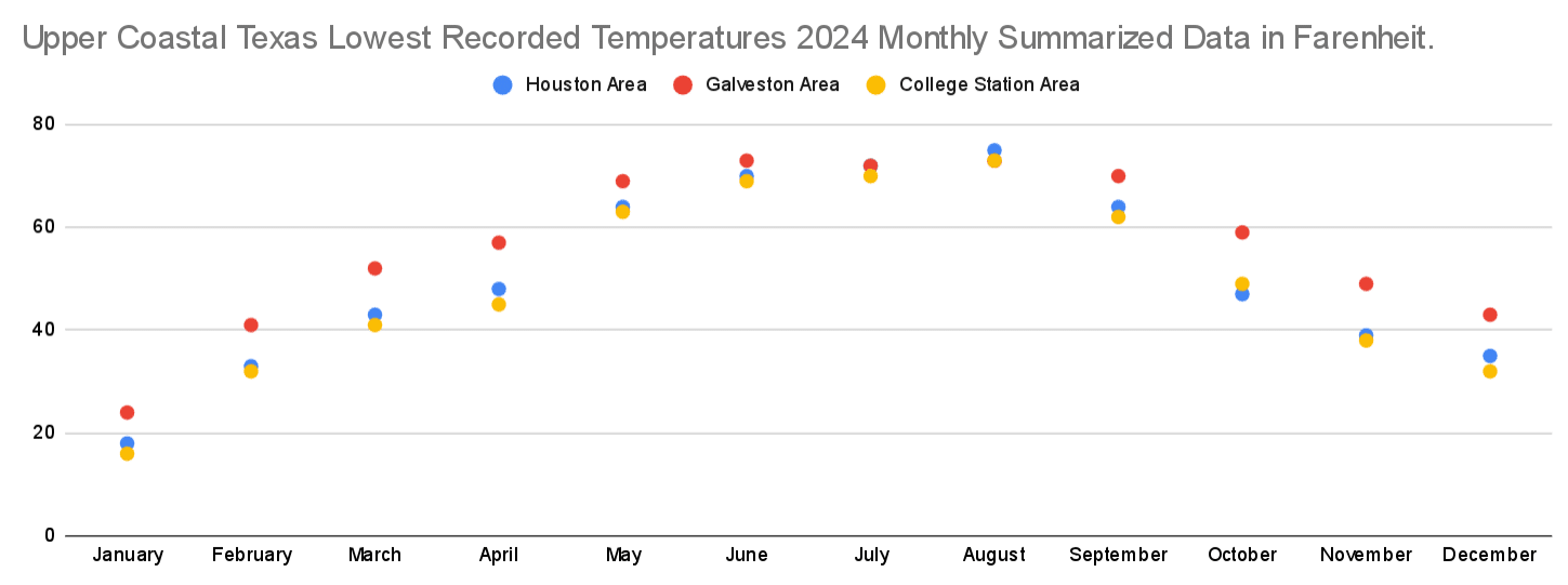
Source: National Weather Service
In 2024, the Upper Coast region of Texas experienced a range of minimum temperatures. Houston recorded its coldest temperature of the year in January at 18°F, with the highest minimum reaching 75°F in August. Galveston, due to its coastal location, had a warmer winter minimum of 24°F in January, while its warmest minimums occurred in July and August at 73°F. College Station, further inland, saw a low of 16°F in January, with its highest minimums also occurring in the summer at 73°F.
The Upper Coast’s winter months were colder throughout 2024, while summer saw higher minimums. Due to its coastal location, Galveston maintained a consistently warmer temperature range than Houston and College Station.
Lower Coast
Source: National Weather Service
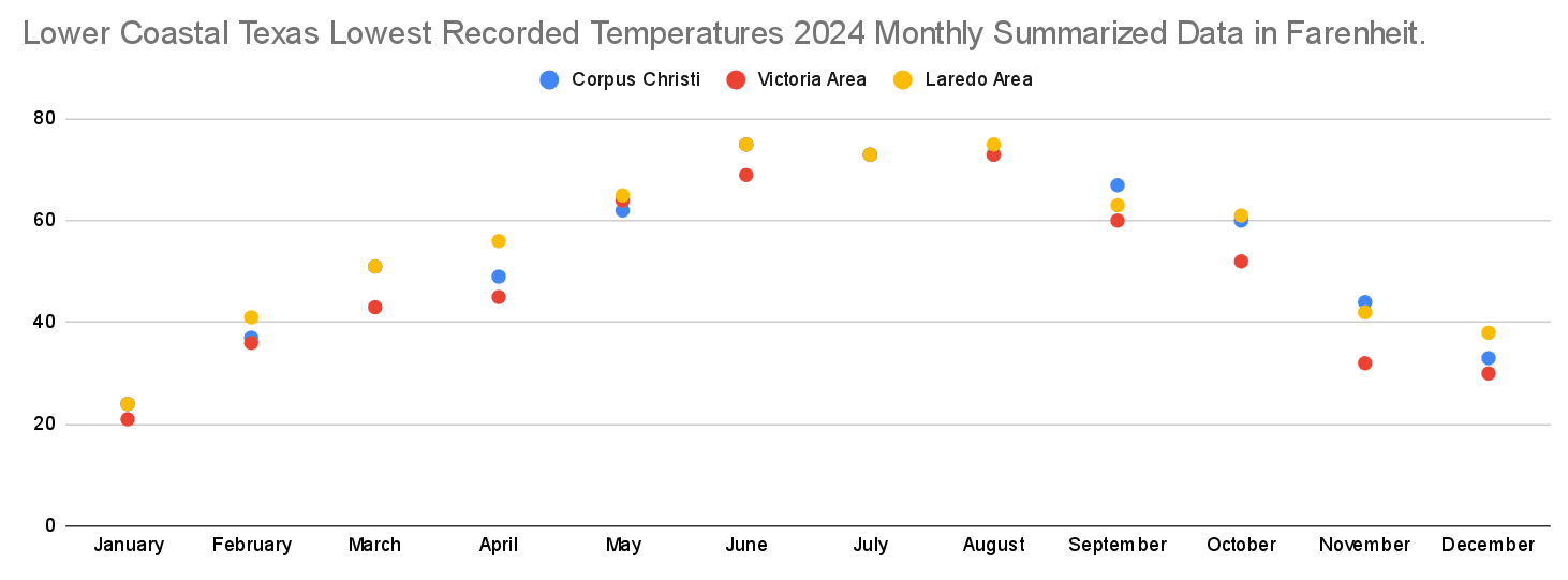
In 2024, the Lower Coast region of Texas had relatively mild winter temperatures compared to other regions. Corpus Christi recorded its lowest temperature in January at 24°F and had a warmest minimum of 75°F in June. Victoria‘s lowest temperature occurred in January at 21°F, while its warmest minimum reached 73°F in July and August. Laredo‘s lowest temperature was recorded in January at 24°F, with the warmest minimums also occurring in the summer months: 73°F in June and July and 75°F in August.
The region’s temperature data reveals a consistent seasonal shift, with mild winter lows and relatively warm summer minimums. Corpus Christi and Laredo exhibited similar patterns, while Victoria saw slightly cooler temperatures in winter, particularly in January.
Major Historical Winter Storms in Texas
Winter Storm Uri 2021
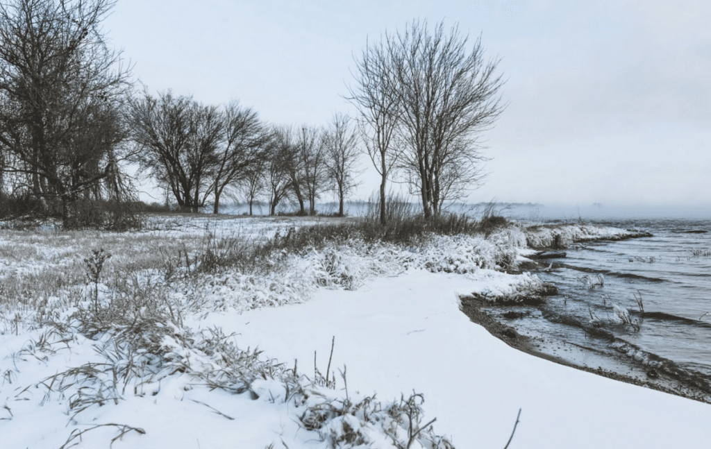
Winter Storm Uri (February 10 to 19, 2021) was one of the most severe winter storms in Texas history, impacting all 254 counties in the state. The storm dumped record amounts of snow and ice, with frigid temperatures dropping below freezing in areas that typically do not experience such cold. Houston recorded its lowest temperature of -13°F, Corpus Christi dropped to -3°F, and Austin saw -2°F.
The storm caused a statewide power grid failure, leaving millions without electricity and water for days. Over 4 million people were affected by power outages, with temperatures dropping as low as -2°F in Dallas and 2°F in San Antonio.
In addition to the power crisis, Winter Storm Uri brought heavy snowfall, freezing rain and ice, creating hazardous road conditions and leading to widespread accidents. Water treatment facilities also failed due to freezing pipes, resulting in a major water supply crisis. The storm caused significant damage to homes, businesses, and infrastructure, and tragically, over 200 people lost their lives due to its direct and indirect impacts.
The storm highlighted vulnerabilities in Texas’ energy infrastructure, particularly the state’s reliance on its isolated power grid. It also showcased the risk associated with index-rate energy plans, with prices soaring due to both the widespread outage and massive demand.
Other Notable Winter Events
- The Great Blizzard of 1957, known as the worst spring blizzard on record, struck the Texas Panhandle in late March, leading to catastrophic consequences. The storm was responsible for 11 deaths and numerous injuries, inflicting $6 million in damage. Snow drifts reached 30 feet in the Texas Panhandle and up to 15 feet in Oklahoma. Reports indicated 10 to 20 inches of snow blanketed the region, resulting in a devastating loss of 20% of the cattle population. Thousands of motorists, including rescue teams operating snowplows, were stranded in enormous drifts. The storm produced true whiteout conditions, reducing visibility to zero at times, paralyzing communities and cutting off essential transportation routes.
- The “Super Bowl Freeze” of February 2011 brought severe winter weather to Texas, affecting the state just before Super Bowl XLV. This Arctic cold front led to blizzard-like conditions in the Panhandle, widespread ice and snow in Dallas/Fort Worth, and frigid temperatures that disrupted daily life. In the Rio Grande Valley, temperatures in the 20s and 30s combined with strong winds, creating wind chills in the teens. Ice accumulation caused dangerous travel conditions, leading to road and overpass closures, particularly on February 4th.
- Winter Storm Goliath, which hit Texas from December 26 – 27, 2015, was fueled by a large upper-level storm system bringing intense cold, high winds and heavy snow to the region. Temperatures fell sharply, and wind gusts of 55 – 65 mph created wind chills in the single digits and teens. Lubbock recorded 11.2 inches of sleet and snow, marking it the third-highest snowfall there. The storm caused widespread travel disruptions, power outages and snow removal challenges that lasted well into the following week, especially in the Panhandle and West Texas.
Impact on Texas Power Grid
Winter weather, especially during storms, can significantly impact the Texas power grid. When temperatures drop drastically during a winter storm, demand for electricity rises because more people use heaters to stay warm. At the same time, winter weather can cause problems with power generation and distribution. For example, ice and snow can build up on power lines and equipment, causing power outages. This happened during winter storm Uri in 2021, when many power plants and equipment froze or failed due to the extreme cold, causing widespread outages across the state.
Historical Grid Performance 2024
Source: US Energy Information Agency
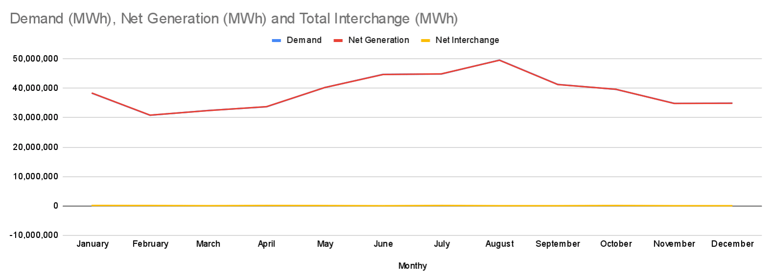
Texas energy demand and net generation show significant monthly fluctuations in 2024. January experienced the highest demand (38,278,184 MWh), with a slight surplus in net generation (63,584 MWh). February and April both saw positive net interchanges, indicating an excess in generation, with February generating 47,194 MWh more than required and April having 55,409 MWh in surplus.
In contrast, March and the summer months (June, August, and September) experienced negative interchanges, reflecting a higher demand than what was generated, especially in June (-44,432 MWh) and August (-27,312 MWh). July had a surplus of 57,915 MWh, whereas October showed a balanced scenario with a surplus of 43,035 MWh. November and December displayed small deficits in net interchange, with December’s being the lowest (-25,787 MWh) despite having lower demand.
Energy Demand During Cold Snaps
Cold snaps significantly increase energy usage due to higher demand for heating, which accounts for the largest share of energy consumption during extreme cold. According to data from the EIA, about six out of 10 homes rely on electricity-powered heating.
As temperatures plummet, residential and commercial heating systems work harder to maintain indoor comfort, particularly in regions where homes and buildings are not designed for such low temperatures. This spike in demand can strain the power grid, sometimes leading to outages if the supply can’t meet the sudden increase in load.
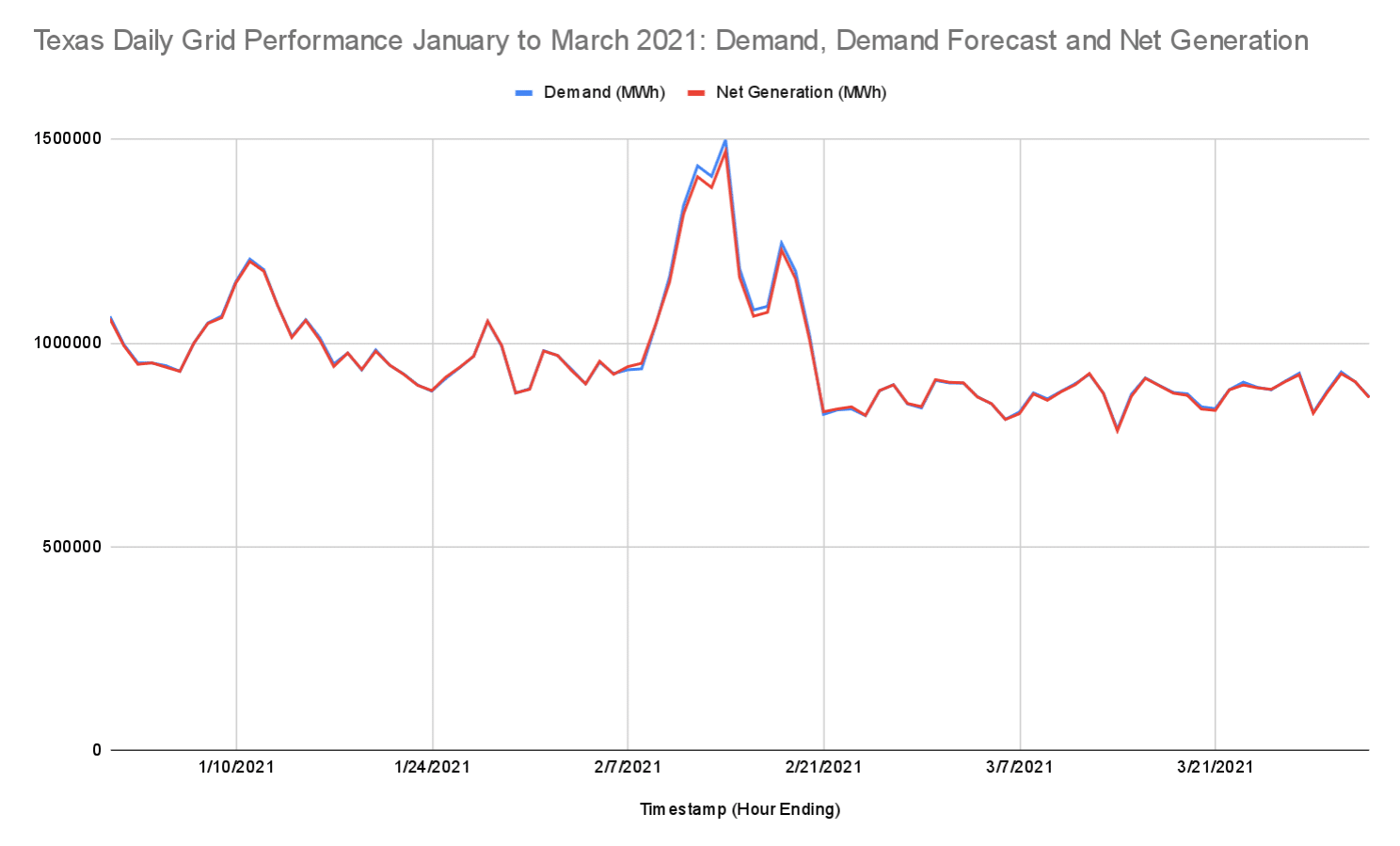
For example, during the February 2021 Texas winter storm, energy demand surged to 50% above typical winter levels. The freezing temperatures also caused supply issues, with both wind turbines and natural gas pipes failing to supply energy at full capacity. The combination of increased demand with flagging power supply led to widespread power outages across the Lone Star State.
Source: US Energy Information Agency
System Preparedness Measures
Texas is implementing several key measures to enhance grid reliability:
- Texas Energy Fund: This $5 billion fund supports natural gas power plants and infrastructure upgrades, addressing the aging thermal fleet to ensure consistent power supply.
- Battery Storage Investments: Large-scale projects like Plus Power’s $1.8 billion initiative will expand battery storage capacity, helping stabilize renewable energy output, especially during periods of low wind or sun.
- Balanced Energy Mix: While wind and solar energy are increasing, natural gas remains crucial for grid stability, particularly during peak demand or extreme weather events.
These measures aim to strengthen the grid, meet Texas’ growing energy needs, and incorporate clean, renewable sources.
Understanding Winter Weather Patterns
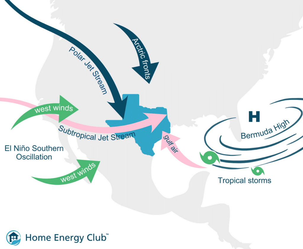
A mix of geographic factors and atmospheric conditions shapes Texas’ climate. Seasonal air masses, such as arctic fronts, subtropical winds and tropical cyclones, interact to create regional variations. The Gulf of Mexico moderates coastal temperatures and supplies rainfall, while the Rocky Mountains funnel cold air southward during colder months. The jet streams and the Bermuda High further influence weather patterns, contributing to temperature extremes and variable rainfall patterns.
Cold arctic fronts, the jet stream and the Bermuda High can interact to push cold, dense air from the north into Texas. These forces can lead to extreme weather events, such as winter storm Uri in February 2021.
Often called the “Great Texas Freeze,” Uri was influenced by a combination of atmospheric factors, including the Arctic Oscillation (AO) and a disruption of the polar vortex. A strongly negative AO during this period caused the jet stream to dip further south, allowing Arctic air to move down into the southern U.S., including Texas. Additionally, a weakened polar vortex contributed to this shift, bringing cold air from the Arctic into the region, leading to extreme freezing temperatures and a prolonged cold snap.
Winter Energy Efficiency Tips
The Department of Energy (DOE) suggests five winter tips to make energy usage more efficient:
- Seal gaps and insulate windows: Weatherproof windows and doors to prevent heat loss. Caulking small gaps, applying weatherstripping and using insulating window covers can help trap warmth inside your home.
- Upgrade your lighting: Swap out incandescent bulbs for energy-efficient LED bulbs. LEDs consume up to 90% less energy and will reduce your winter energy bills.
- Use a programmable thermostat: Lower your thermostat by 7 – 10 degrees while you’re away or asleep to save up to 10% annually on heating costs. Consider programming your thermostat to automatically adjust to your schedule.
- Perform routine maintenance: Clean or replace filters regularly to keep heating systems running efficiently. A well-maintained furnace or heating system uses less energy to keep your home warm.
- Bundle up and use fans: Dress in layers and use ceiling fans to circulate warm air. Fans can help push warm air from the ceiling into the living space without increasing the room temperature.
Preparing for Extreme Cold Events
Multiple government agencies have published preparation measures for extreme cold weather events. Here are five tips for preparing for extreme cold events:
- Prepare your home: Insulate your home and seal any drafts with weather stripping to keep the cold out. Protect your pipes from freezing and ensure smoke alarms and carbon monoxide detectors are functioning with battery backups.
- Create an emergency kit: Assemble essential supplies, such as non-perishable food, water, medications, warm clothing and blankets. Ensure your cold-weather emergency kit includes batteries for flashlights and radios in case of power outages.
- Stay informed: Pay attention to weather reports and warnings. Sign up for community emergency alerts and use NOAA weather radios for real-time updates.
- Limit outdoor exposure: If you must go outside, wear multiple layers of warm clothing to reduce the risk of frostbite or hypothermia. Stay indoors as much as possible during extreme cold.
- Carbon monoxide safety: Use generators and grills outdoors, away from windows, and never indoors. Also, avoid heating your home with a stove or oven.
The Bottom Line
While Texas is known for its warm summers and fairly mild winters, the Lone Star State is no stranger to Arctic weather. Unpredictable winter weather patterns often lead to sudden cold snaps that can last for days or even weeks. These extreme weather events strain the local power grid, making it critical for Texans to prepare their homes. While the Electric Reliability Council of Texas (ERCOT) and the Public Utility Commission of Texas (PUCT) are working together to improve the power grid to be more reliable during extreme winter weather events, you can do things to prepare your home in the event of a sudden cold snap or polar weather event.
Frequently Asked Questions About Cold Weather in Texas
The lowest temperature ever recorded in Texas was -23°F on February 8, 1933, in Seminole.
The city of Amarillo experiences the coldest winters, with temperatures reaching -5°F.
Texas experiences freezing temperatures mainly during winter. Northern and central areas experience them more often, while southern regions experience them infrequently.
The longest cold snap in Texas history occurred during winter storm Uri from February 10 to February 19, 2021, lasting about seven days and resulting in widespread power outages and severe disruptions.

